We hiked the JMT Northbound starting at Cottonwood Pass and finishing at Happy Isles over 19 days with 1 day for resupply from Onion Valley.

This was our rough itinerary and elevation gain/loss as reported by caltopo.com:
Enjoy some of the spectacular vistas from the hike below!
Day 0 - Driving from San Jose to Horseshoe Meadow campground
We started the day super excited, and a bit scared from our house in San Jose. In order to make the point to point trip easier, we had decided to drive 2 cars from here, leave one at our end point - Yosemite Valley and the other at Horseshoe Meadow Campground. We loaded all our supplies for our 19 day trip in the car which needed to go to the starting point, and left a pair of clean clothes in the endpoint car to change into when we finish. It was a long lonely drive on a very hot day, and took us about 4 hours to get to Yosemite Valley. The day was July 3rd, and the valley was busy with folks pouring in for the long weekend. With the swarms of people, it wasn't surprising that the road to the backpackers parking was closed about a mile before with a 'Parking lot full' sign. We drove back to the visitor center parking. After driving around the visitor center parking for 20 minutes and waiting for someone to leave, a kind gentlemen waved at me telling me that he was leaving and I quickly snagged the spot. Driving towards our destination on Tioga road, we saw a lots of beautiful wild flowers along the road, which reminded me of why I wanted to do this and took the bit of apprehension left out of me. It took us another couple of hours to get to the Mono lake interagency visitor center. We got our wilderness permit from 2 fun rangers, who were wondering how we managed to get so much time off work. We stopped in Lone Pine to eat burgers at the Mount Whitney restaurant, and picked up a couple sandwiches for breakfast next morning. We drove up the beautiful winding road up to Horseshoe Meadow (10,000 ft ASL) and reached there by 7 p.m. After setting up camp, we played some cards and went to bed, excited at what the next day had to offer.
Day 1 - Horseshoe Meadow to Rock Creek
After a good nights sleep, and trying to shove the tomato and cheese sandwich down my throat without throwing up, we started our 220 mile long journey. After walking along the meadow for a bit, the trail quickly started climbing up to cottonwood pass. There were flowers in all shapes and sizes, showing us what the Sierra's had in store for us. Being the first day at high altitude, I made sure to drink water every 15-20 mins and eat every hour. It worked because I didn't feel any altitude sickness this day, or any other days on the trail (tad bit unusual from my previous experiences). I made good time getting up the pass where we took a break and ate some food. It was a short walk from there to Chicken Spring lake, our first lake on the trip. The rest of the day remains in my hazy memory a dry trail with no water. We finally came down a bunch of steep switchbacks that led us to an offshoot of rock creek, and we decided to make camp there. I sat in the cold creek, washing off the dust and giving my feet some relief. After a dinner of soup and rice, my sleeping pad looked really comfortable and I promptly fell asleep.

View of Horseshoe Meadows from the top of Cottonwood Pass
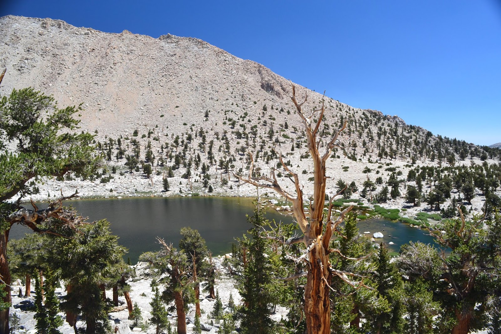
The first lake of the hike - Chicken Spring Lake, just pass Cottonwood Pass

Crossing Rock Creek - our campsite for the night
Day 2 - Rock Creek to Crabtree Meadow
This was slated to be an easy day, with only 7 miles to be covered. The walk started with us crossing the actual rock creek, which was mostly rock hopping. The day was mostly mild ups and downs, however at the time they certainly did not seem mild. I stumbled along, taking in some nice views of the mountains around, and soon we were at Crabtree Meadow. We setup camp right in front of a rock which was home to a huge marmot family. We saw a mother marmot with lots of babies frolicking on the rock as well as the beautiful meadow. We took a dip in the stream, cleaned ourselves and settled in for the night taking in beautiful vistas of the mountains.

Mt. Whitney up and center from Lower Crabtree Meadow

The lookout for the marmot family that called this place home

A panorama of Lower Crabtree Meadows

Crabtree lakes - a short evening hike from the meadow
Day 3 - Crabtree Meadow to unknown lake below Forester pass
Day 3 was going to be a long day, we got up early, ate some breakfast, packed our bags and started our walk. The initial few miles were extremely pleasant, with a nice uphill followed by a gorgeous meadow which I remember from our High Sierra Trail trip the earlier year. We took a short snack break at the meadow, and then started the switchbacks up towards Wallace creek. The weather was pleasant and we reached Wallace creek fairly quickly. The water level in the creek was lower than the level in September last year, showing the difference in the snowpacks. We took a little break to wash our feet in the cold water and started walking towards Bighorn Plateau. The trail climbed steadily, and I started to get a bit tired and hoping for a downhill which just didn't seem to come. On the plus side, the vistas were beautiful, we could see Whitney and surround peaks to the south, and Williamson and Tyndall in front of us. We took a short lunch break at the top of a ride we finished climbing, and then continued the grind towards Bighorn Plateau. After what seemed like forever, we finally reached there, and it was perhaps one of the most beautiful places on the entire trail. Magnificent mountains on all sides, with a gorgeous valley between the meadows and mountains, and an absolutely spectacular lake in front of us with millions of wildflowers. Since we still had a while to go to set ourselves up well for Forester pass, we chugged along and to my relief, there was a nice downhill towards Tyndall Creek. We were soon at Tyndall Creek where we rock hopped to cross it and then took a short break in the shade. The rest was followed by another steady uphill. We had initially planned to camp at a lake called Lake South, but the lake beyond a ridge which we didn't realize till we were far away from it. We decided to continue along and stop at the next available campsite. I was so exhausted that we finally decided to camp next to the trail while it was still going uphill with a lake below it, with just enough space for a tent and a tiny trickle of stream which seemed enough for the night. I promptly setup my bed and crashed in the tent to rest. After a dinner of soup and some rice, I was ready to crash. We played a couple card games, and I slept without the rain fly. Even though I was tired, I enjoyed the sunset on the mountains in front of us a lot, and slept while seeing the golden glow.
On the meadow between Crabtree and Wallace Creek - a view we recalled from the HST a year ago

Spectacular high sierra scenery enroute the Bighorn Plateau

Looking across towards Mt. Tyndall

Looking back towards Mt. Whitney
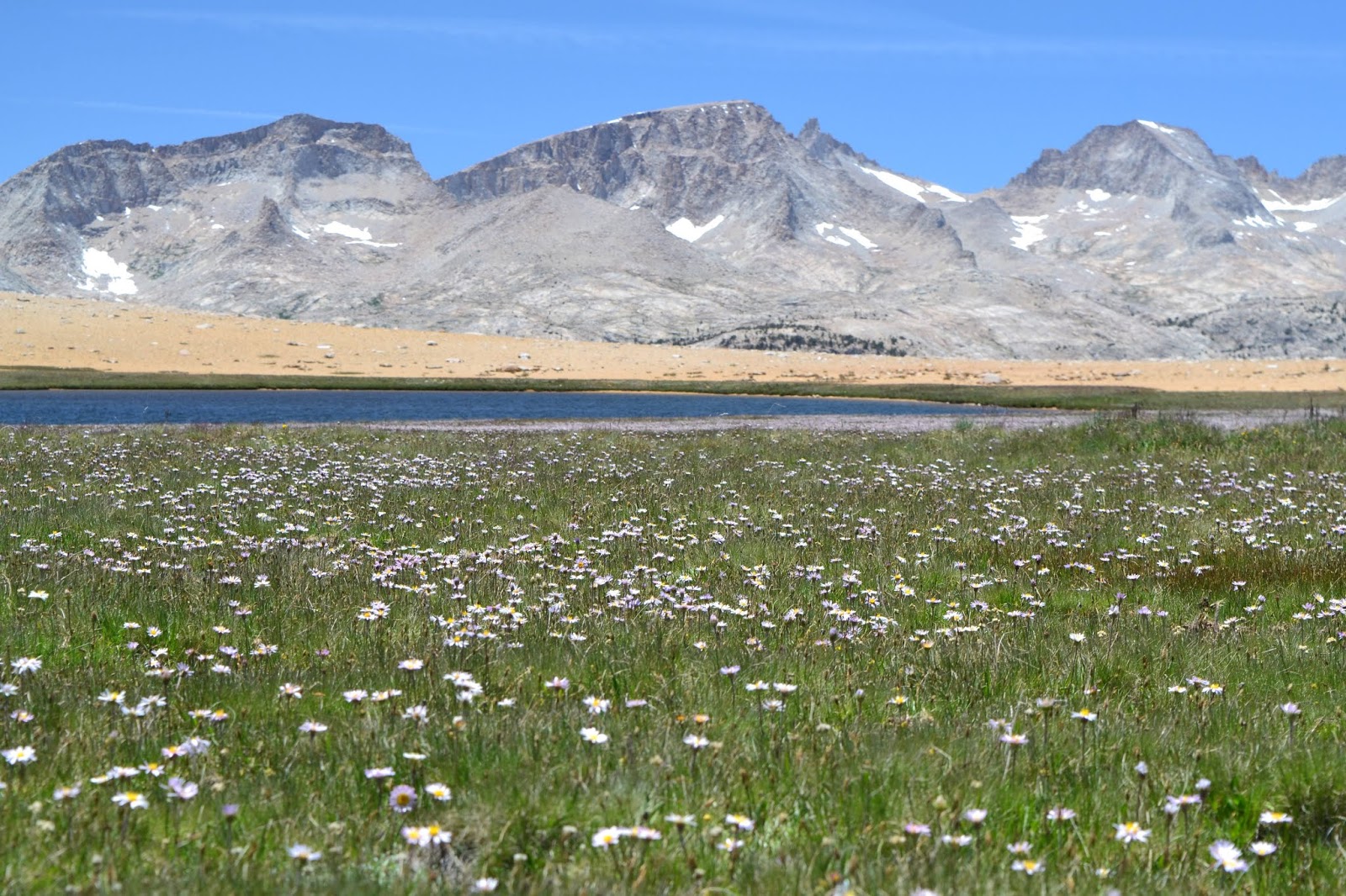
Bighorn Plateau - one of the best regions of the JMT

A panorama during the descent from the Bighorn Plateau

Crossing Tyndall Creek

Spectacular views enroute Forester Pass
Day 4 - Unknown lake below Forester pass to Bubb's creek junction
I got up early and was ready for a long climb to Forester pass. Today was the beginning of a long series of days where I would leave camp after eating at breakfast by 7-7.30, and PJ would leave a couple hours later while I get my head start. While we were getting ready, we met an old man from Australia, perhaps in his 70s, who was doing the PCT. Despite a back problem, he was chugging along and enjoying the journey. Part of the experience of the trail is meeting some amazing people, and learning how to hike your own hike. He talked about how he was trying to get his wife to come with him, but since she didn't agree he decided to come out on his own. As he carried on, I quickly packed and started the hike up to Forester. The alpine scenery was beautiful and I enjoy the uphill through some beautiful meadows and lakes. I had to finally wait just below the final ascent to the pass for PJ to filter water for the pass and beyond since that was the last water source. After enjoying the marmots playing near the lake, we started our final climb up to the pass. It was very hard to see the pass at first, since it really looked like we were climbing up a peak. Some folks coming from the other side pointed towards a notch in the mountains and we could then finally see the pass. The trail is an absolute engineering marvel, everyday I couldn't think of how much we had to thank USFS/NPS for their hard work. I made slow and steady progress up the pass, and was there is no more than 45 minutes. There was a small party on the top of the pass with people cheering folks climbing up from both sides on. The view from the top was absolutely gorgeous, with pristine blue lakes on both sides, and skypilots (an indigenous plant from the high altitude of the sierras) everywhere. After a snack break and some friendly chit chat, we started our descent. The first few miles were littered with lakes and made for a fun hike. As the hours went on, the downhill became brutal. It took only 2 hours to get down to Vidette meadow but seemed like longer. There was another thousand feet of climbing to do before we would reach Bubb's creek, our camp for the next 2 nights. We found a nice (but crowded campsite) next to the creek. After cleaning up in the creek, we had dinner and chatted with our camp neighbors before we settled in for the night
Lakes enroute Forester Pass on the south side

View to the south from the top of Forester Pass

At the top of Forester Pass

View to the north from the top of Forester Pass

View enroute the descent from Forester

Lake at the north end of Forester Pass

Lake at the north end of Forester Pass

View enroute the descent from Forester Pass

East Vidette Peak from Bubbs Creek
Day 5 - Rest and resupply day
The next day was a rest day for me while PJ went to pick up our resupply package from Independence. He left early and I lazed around in the tent for a while. I woke up and had some breakfast, and chatted with the nice couple from the bay area who were also taking a rest day there. I did laundry and then again slept in and relaxed. Not hiking on the trail made me kind of restless and I wondered if I should have gone to bullfrog but laziness got the better of me. As more people started coming in to the campsite, it became a nice social gathering with lots of fun conversations from politics to wine making. PJ finally came back at 5 after a long and apparently fun day of hiking and was greeted by a lot of people who just had heard about him but not met him. Soon after cooking dinner, we realized that we were using more fuel than we anticipated and our fuel canister in the resupply package wouldn't last us till Muir Ranch. Thankfully, a nice couple from France who were heading out to Independence the next day gave us an almost full, double sized canister of fuel. We ended the day with cards as usual. I couldn't wait to get back on the trail the next day.
Panorama of Bullfrog Lake at dawn

Kearsarge Lakes

Kearsarge Lakes

View from the top of Kearsarge Pass

Big Pothole Lake from the top of Kearsarge Pass
Continue to Part 2 here ...


